drone panorama
Drone Panorama: The Complete Guide for Photographers and Real Estate Agents
I. Introduction
A. What is a Drone Panorama?
A drone panorama is a wide or 360-degree image. It is created by stitching together multiple photos taken from a drone in the sky. These high-resolution images offer sweeping views of landscapes, buildings, or properties from above. When shared on platforms like www.threesixty.tours, they become interactive experiences. This allows viewers to explore a scene as if they were flying through it.
B. How Drone Photography Evolved
Drone photography has come a long way since the early 2000s. Back then, drones were clunky and hard to control. However, the rise of consumer-friendly UAVs changed everything. By the mid-2010s, drones featured 4K cameras, GPS, and gimbals for stability. This made panoramic drone shots accessible to photographers and real estate professionals alike.
C. Why Drone Panoramas Matter Today
In today’s digital-first world, visual content is king. Drone panoramas offer a fresh, immersive way to tell stories. Whether capturing a mountain range or a luxury home, they can showcase a property and its surroundings in one sweeping view. Uploading them to www.threesixty.tours turns these visuals into virtual tours. This engages buyers and boosts sales.
II. Technology Behind Drone Panoramas
A. Choosing the Right Drone
-
1. Professional-Grade Drones
If you’re serious about quality, consider drones like the DJI Mavic 3 Pro, DJI Inspire 3, or Autel EVO II Pro. These machines feature large sensors, top-tier lenses, and precise flight controls. They’re perfect for commercial work or high-end real estate listings where every detail matters.
-
2. Consumer Drones
Just starting out? Drones like the DJI Mini 4 Pro or DJI Air 3 are budget-friendly and still pack a punch. Many offer panorama modes and solid resolution. They are great for beginners or agents looking to dip their toes into drone photography.
B. Must-Have Features for Panoramas
-
1. Camera Specs
Look for drones with at least a 1-inch sensor and 20MP resolution. A wide-angle lens helps capture more of the scene, reducing the number of shots needed. Features like HDR and adjustable apertures are also helpful in tricky lighting.
-
2. Flight Stability
Smooth flight is key. A drone with a 3-axis gimbal, GPS, and obstacle sensors ensures your shots are steady and aligned. This helps avoid stitching errors when you combine the images later.
C. Stitching Software
-
1. Best Tools for the Job
Once your photos are taken, you’ll need software to stitch them into a panorama. Top choices include Adobe Lightroom, PTGui, and Hugin. These tools align your images, correct perspective, and blend lighting for a seamless result.
-
2. Choosing the Right One
Pick software that fits your skill level and workflow. For example, PTGui offers advanced control, while Lightroom is more user-friendly. Ensure your software can export high-res JPEG, TIFF, or PNG files—ideal for uploading to www.threesixty.tours. Bonus points for 360-degree equirectangular output.
III. Techniques for Capturing Stunning Drone Panoramas
A. Camera Settings
-
1. Exposure, ISO, and Shutter Speed
Manual settings provide consistency. Set ISO low (100–200) to reduce noise. Use the same shutter speed for all shots to avoid exposure differences. Lock your settings before shooting so your images match perfectly.
-
2. RAW vs. JPEG
Always shoot in RAW if possible. RAW files hold more detail and are easier to edit. JPEGs are quicker to process but can lose quality and make stitching harder.
B. Flight Planning
-
1. Altitude and Camera Angles
Your flying height affects your shot. For real estate, stay between 30–60 meters. This provides a good view of the property and neighborhood. Tilt your camera slightly down to include both the ground and horizon for depth.
-
2. Flight Paths
Use a grid or spiral pattern to cover the area. Overlap each photo by at least 30% so the software can stitch them accurately. Many drones have automated modes that handle this for you.
C. Lighting and Timing
-
1. Best Time to Shoot
Golden hour—just after sunrise or before sunset—is ideal. The soft light adds warmth and reduces harsh shadows. Avoid midday when the light is flat and unflattering.
-
2. Weather Tips
Always check the weather before flying. Wind can shake your drone, and overcast skies can dull your image. Use apps like UAV Forecast to plan your shoot safely.
IV. Creative Uses for Drone Panoramas
A. Landscape Photography
Drone panoramas are perfect for capturing vast scenery. Think mountains, coastlines, forests, or deserts. These images can be turned into fine art prints or shared in virtual galleries. Upload them to www.threesixty.tours to let viewers explore your work in 360 degrees.
B. Urban and Architectural Photography
Cities look amazing from above. Use drone panoramas to highlight skyline views, building symmetry, or urban design. It’s a great way to show how a structure fits into its environment—something ground-level shots can’t always do.
C. Real Estate and Events
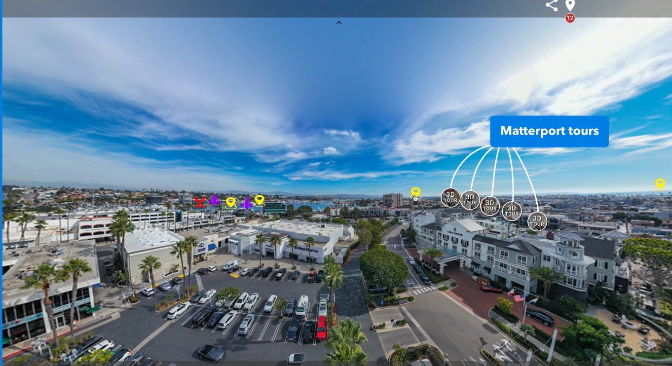
For real estate, drone panoramas can showcase a home, yard, and neighborhood all in one image. Upload these to www.threesixty.tours to create interactive listings that buyers can explore from anywhere. Event planners can also use panoramas to show off venues, festivals, or weddings in a dynamic, engaging way.
D. Social Media and Storytelling
Drone panoramas are eye-catching and perfect for platforms like Instagram or Facebook. Use them to tell stories, share behind-the-scenes footage, or promote new projects. When combined with virtual tours, they offer a rich, interactive experience that keeps followers hooked.
V. Legal and Ethical Considerations
A. Drone Laws You Need to Know
-
1. FAA Rules
In the U.S., the FAA requires drone pilots to follow specific rules. Keep your drone below 400 feet, stay within visual line-of-sight, and avoid restricted areas. If you’re flying for business, you’ll need a Part 107 certification. Learn more at the FAA’s official site: https://www.faa.gov/uas/.
-
2. Local Laws
Some cities have extra rules. Always check local ordinances and use apps like B4UFLY or AirMap to see where you can and can’t fly. Ignoring these rules can lead to fines or worse.
B. Privacy Matters
Be respectful when flying near homes or people. Don’t photograph individuals without consent, and avoid flying over private property unless you have permission. Use zoom or cropping to remove sensitive areas if needed.
C. Flying in Nature
If you’re shooting in parks or nature reserves, follow all posted rules. Don’t disturb wildlife or damage the environment. Ethical flying protects not just the land—but your reputation too.

VI. Tips for Better Virtual Tours on Threesixty.tours
-
1. Upload High-Quality Panoramas
Make sure your stitched images are high-res and properly aligned. Threesixty.tours supports large file sizes and 360-degree formats, so take advantage of that.
-
2. Add Interactive Hotspots
Use Threesixty.tours to add clickable hotspots that link to videos, maps, or other panoramas. This makes your tour more engaging and informative.
-
3. Customize Your Tour
Add your branding, include contact info, and embed the tour on your website or social media. With Threesixty.tours, you can create a polished, professional experience that keeps viewers coming back.
VII. Future Trends in Drone Panorama Technology
-
1. Smarter Drones
Expect drones to get even smarter. Features like AI-assisted flight paths, automatic panorama capture, and real-time stitching are already in development.
-
2. Real-Time 360 Streaming
Soon, you’ll be able to stream 360-degree drone footage live. This opens up new possibilities for virtual events, live property tours, and real-time storytelling.
-
3. Better Integration with Platforms
Tools like www.threesixty.tours will continue to evolve. They will offer better editing, analytics, and customization, making it easier than ever to share your work and track engagement.
VIII. Final Thoughts
Drone panoramas are changing the way we capture and share the world. Whether you’re a photographer looking to expand your portfolio or a real estate agent wanting to stand out from the crowd, these immersive images offer a powerful edge.
With the right drone, smart techniques, and a platform like www.threesixty.tours, you can turn your aerial shots into interactive experiences. This will wow your audience and drive results.
Ready to take your drone panoramas to the next level? Sign up with www.threesixty.tours and start creating unforgettable virtual tours today.